
| Core Metric | Alappuzha District Details |
|---|---|
| Geographical Location / Status | Coastal district in south-central Keralam. It lies between the Arabian Sea, Vembanad Lake, Kuttanad wetlands, rivers, canals, and backwaters. |
| District Headquarters | Alappuzha |
| Total Land Area in sq km | 1,415 sq km as shown on the official demography page. One official district-profile page also displays 1,414 sq km, so 1,415 sq km should be verified before official reuse. |
| Population as per latest available Census data | 2,127,789 as per Census 2011, the latest completed Census data available publicly. |
| Literacy Rate | 95.72% as per Census 2011 data published through Keralam official statistical sources. |
| Number of Rivers / Major Rivers | 3 major rivers officially listed: Manimala, Pamba, and Achankovil. |
| Revenue Divisions | 2 revenue divisions: Alappuzha and Chengannur. |
| Taluks | 6 taluks: Cherthala, Ambalappuzha, Kuttanad, Karthikappally, Chengannur, and Mavelikkara. |
| Municipalities | 6 municipalities: Alappuzha, Chengannur, Cherthala, Kayamkulam, Mavelikara, and Harippad. |
| Number of Grama Panchayats | 72 grama panchayats. |
| Assembly Constituencies | 9 assembly constituencies: Aroor, Cherthala, Alappuzha, Ambalappuzha, Kuttanad, Haripad, Kayamkulam, Mavelikkara, and Chengannur. |
| Lok Sabha Constituency / Constituencies | Alappuzha and Mavelikkara Parliamentary Constituencies. |
| Official District Website | Official District Administration Website: District Alappuzha, Government of Keralam. |
What Makes Alappuzha Unique?
Alappuzha district is one of Keralam’s most water-linked districts. Its public identity is shaped by the Arabian Sea, Vembanad Lake, Kuttanad, rivers, canals, and backwater settlements.
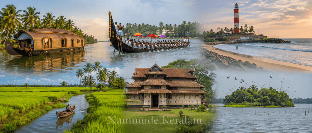
Alappuzha Keralam is widely known for backwater tourism. Keralam Tourism describes Alappuzha as a world-renowned backwater destination. It is also linked with boat races, beaches, marine products, and the coir industry.
The district has a strong coastal identity. Its official rivers and lakes profile records an 82 km flat and unbroken sea coast. This forms about 13.9% of Keralam’s coastline.
Kuttanad gives Alappuzha district a rare agricultural identity. It is called the Rice Bowl of Keralam. Keralam Tourism notes that farming is carried out up to two metres below sea level in Kuttanad.
Alappuzha also has historic importance. The district was formed on 17 August 1957. The old port town grew through trade, canals, bridges, and inland waterways. Official district history records the role of Diwan Raja Kesava Das in developing the town.
The district’s culture is linked with boat races, temple festivals, church feasts, coastal livelihoods, coir work, paddy farming, and backwater life. Malayalam is the main language. English is used in administration, education, tourism, and public services.
Geography and Administrative Profile
Location in Keralam
Alappuzha district is located in south-central Keralam. It is a coastal district facing the Arabian Sea.
The district is bordered by Ernakulam district to the north. Kottayam and Pathanamthitta lie to the east. Kollam district lies to the south. The Arabian Sea forms the western boundary.
Alappuzha local information is strongly connected to water systems. Many settlements are shaped by canals, lagoons, rivers, lakes, beaches, paddy fields, and inland transport routes.
Rivers, Lakes, Backwaters, and Coast
The major rivers are Manimala, Pamba, and Achankovil. These rivers connect the eastern side of the district with Kuttanad and Vembanad Lake.
Vembanad Lake is one of the district’s defining water bodies. The official profile describes it as a major part of the west coast canal system. It extends from Alappuzha to Kochi and borders Cherthala, Ambalappuzha, and Kuttanad taluks.
Kayamkulam Lake is another important water body. The official district profile records its area as 59.57 sq km and length as 30.5 km.
The district also contains canals used for navigation. These waterways have supported passenger movement, goods movement, fisheries, tourism, and local trade.
Revenue Divisions and Taluks
Alappuzha district administration is divided into two revenue divisions.
The Alappuzha Revenue Division includes Ambalappuzha, Cherthala, and Kuttanad taluks. The Chengannur Revenue Division includes Karthikappally, Chengannur, and Mavelikkara taluks.
The Alappuzha taluks are:
| Taluk | Revenue Division |
|---|---|
| Cherthala | Alappuzha |
| Ambalappuzha | Alappuzha |
| Kuttanad | Alappuzha |
| Karthikappally | Chengannur |
| Chengannur | Chengannur |
| Mavelikkara | Chengannur |
Municipalities and Panchayat Structure
Alappuzha municipalities are Alappuzha, Chengannur, Cherthala, Kayamkulam, Mavelikara, and Harippad. These towns act as major civic and commercial centres.
The district has 72 grama panchayats and 12 block panchayats. It also has 93 revenue villages.
Major Towns and Urban Centres
Important towns include Alappuzha, Cherthala, Kayamkulam, Mavelikkara, Chengannur, Harippad, Ambalappuzha, and Aroor.
Alappuzha town is the district headquarters. Chengannur and Kayamkulam are important transport-linked towns. Cherthala connects the northern side of the district with Ernakulam. Mavelikkara and Harippad are important civic, educational, and cultural centres.
Major Places to Know in Alappuzha
| Place | Location | Why It Is Important | Factual Claim to Fame | Short Description |
|---|---|---|---|---|
| Alappuzha Backwaters and Punnamada Lake | Alappuzha town and nearby backwater areas | Major backwater and houseboat zone | Punnamada Lake is associated with the Nehru Trophy Boat Race, one of Keralam’s most popular boat races. | This area is central to Alappuzha tourist places. It links tourism, inland waterways, boat races, and local livelihoods. |
| Kuttanad and R-Block | Kuttanad taluk | Paddy farming and below-sea-level landscape | Kuttanad is known as the Rice Bowl of Keralam and has farming below sea level. | Kuttanad is one of the most distinctive agricultural landscapes in Keralam. R-Block is linked with reclaimed backwater farming protected by dikes. |
| Alappuzha Beach and Lighthouse | Alappuzha town | Coastal landmark and public recreation area | The district tourism page notes an old pier and lighthouse at Alappuzha Beach. | Alappuzha Beach represents the district’s coastal character. It is also connected to the old port history of the town. |
| Krishnapuram Palace | Near Kayamkulam, Karthikappally taluk | Historic palace and museum | It is known for the large mural painting “Gajendramoksham.” | Krishnapuram Palace was built during the Travancore period. It now functions as an important heritage and museum site. |
| Pathiramanal Island | Vembanad Lake, between Thanneermukkom and Kumarakom route | Lake island and bird habitat | The official district page describes it as a small island with biodiversity and migratory birds. | Pathiramanal is accessible by water. It is important for lake ecology and backwater tourism. |
Citizen Services and Local Infrastructure in Alappuzha
Administrative Centers
The District Collectorate is located in Alappuzha. It is the main administrative centre for district-level governance.
The district has two Revenue Divisional Offices. The Alappuzha RDO covers Ambalappuzha, Cherthala, and Kuttanad taluks. The Chengannur RDO covers Karthikappally, Chengannur, and Mavelikkara taluks.
Taluk offices operate in Cherthala, Ambalappuzha, Kuttanad, Karthikappally, Chengannur, and Mavelikkara. These offices support land records, certificates, revenue services, and citizen applications.
Local self-government services are delivered through municipalities, block panchayats, and grama panchayats. The district has 6 municipalities, 12 block panchayats, and 72 grama panchayats.
The district police system includes police stations across urban, coastal, and rural areas. The official district overview records 36 police stations.
The District and Sessions Court functions at Alappuzha. Court complexes also serve major centres such as Mavelikkara, Cherthala, Chengannur, and Haripad.
Health Infrastructure
Alappuzha has important public health facilities at district, taluk, and local levels.
The official district profile records one government medical college, two district hospitals, one general hospital, five taluk hospitals, 16 community health centres, and 59 primary health centres. It also records Ayurveda and Homoeopathy institutions in the district.
Important public health institutions include:
| Institution Type | Examples / Notes |
|---|---|
| Government Medical College | T.D. Medical College, Vandanam |
| General Hospital | General Hospital, Alappuzha |
| District Hospitals | District Hospital, Chengannur; District Hospital, Mavelikkara |
| Taluk Hospitals | Taluk-level government hospitals across major taluk centres |
| Community Health Centres | CHCs listed across locations such as Ambalappuzha, Champakulam, Chettikadu, and other centres |
| Primary Health Centres | Local PHCs supporting panchayat-level public health |
The official hospital directory lists District Hospital Chengannur, District Hospital Mavelikkara, General Hospital Alappuzha, and multiple community health centres.
Education Infrastructure
Alappuzha district has government, aided, professional, technical, and medical education institutions.
The official district profile records 197 high schools, 151 upper primary schools, 260 lower primary schools, and 11 higher secondary schools. It also records technical training institutions and colleges.
Important institutions include T.D. Medical College, Government colleges, aided colleges, engineering colleges, polytechnic institutions, nursing colleges, and teacher education institutions.
The official public-utilities directory lists institutions such as College of Engineering Chengannur, College of Engineering Cherthala, Carmel College of Engineering and Technology, Sanatana Dharma College, St. Joseph’s College for Women, MSM College, and T.D. Medical College.
Transport Infrastructure
Alappuzha is connected by road, rail, inland waterways, and nearby airports.
The district has no major commercial airport inside its boundary. The nearest major airport is Cochin International Airport. The official “How to Reach” page lists Cochin International Airport at 82.8 km via NH 66. It also lists Thiruvananthapuram International Airport at 149 km via NH 66.
Alappuzha is connected by National Highway 66. The official district page places Alappuzha 62 km south of Kochi and 155 km north of Thiruvananthapuram through NH 66.
Major railway stations include Alappuzha, Chengannur, and Kayamkulam Junction. These stations connect the district with major Keralam and interstate rail routes.
Water transport is important in Alappuzha citizen services and local travel. The district’s lakes and canals support inland movement, tourism, and public transport. The official rivers and lakes profile notes that canals are used for inland passenger and goods transport.
Economy and Local Livelihoods
Alappuzha district has a mixed economy. It is shaped by water, coast, agriculture, tourism, coir, fisheries, trade, and services.
Agriculture
Kuttanad is the most important agricultural identity of Alappuzha district. It is known for paddy cultivation and below-sea-level farming. This makes the district important in Keralam’s food and wetland geography.
Coconut cultivation is also common. It supports local food, coir, small industries, and household livelihoods.
Fisheries and Marine Livelihoods
The Arabian Sea coast, lakes, canals, and backwaters support fishing communities. Inland fisheries and marine fisheries are both important to the district’s economy.
The official rivers and lakes profile links Alappuzha’s waterways with fisheries, transport, and local use.
Coir and Small Industries
Alappuzha has a long association with the coir industry. Keralam Tourism identifies coir as one of the district’s known economic features.
Coir work is linked with coconut, household production, small industries, and traditional labour networks. It remains part of the district’s public and industrial identity.
The official district profile records 8,830 registered industrial units.
Tourism and Services
Tourism is a major service-sector driver. Houseboats, backwater cruises, hotels, homestays, transport, food services, guides, boat operators, and local markets depend on visitor movement.
The district tourism page lists houseboat, shikara, motorboat, and speedboat services arranged around Vembanad Lake and Alappuzha backwater routes.
Trade and Transport
Alappuzha’s economy has long depended on waterways and coastal trade. Official district history records the role of the old port, canals, bridges, and inland connectivity in the town’s growth.
Today, road, rail, and water links support trade, commuting, tourism, agriculture, and fisheries.
Culture, Language, and Society
Malayalam is the main language of Alappuzha district. English is widely used in administration, education, tourism, and formal communication.
The district’s social life is shaped by coastal settlements, backwater villages, paddy fields, market towns, religious centres, schools, colleges, and migrant employment.
Boat races form an important cultural identity. The Nehru Trophy Boat Race at Punnamada Lake is one of the most recognized events connected with Alappuzha Keralam.
Major religious and heritage centres include Ambalappuzha Sree Krishna Temple, Arthunkal Church, Champakulam Church, Saukar Masjid, Mannarasala Temple, and Chettikulangara Devi Temple. The official district tourism page lists these as important places of worship and heritage.
Traditional culture is also linked with temple festivals, church feasts, mosque heritage, boat-building skills, coir work, paddy farming, and fishing life.
Food identity is influenced by rice, fish, coconut, toddy-shop cuisine, backwater fish dishes, and coastal Keralam cooking. Ambalappuzha is also strongly associated with the Sree Krishna Temple and its famous temple offering.
Alappuzha local information is therefore not only administrative. It is also cultural, agricultural, coastal, and water-based.
Suggested Official Sources to Verify
Official District Administration Website
Keralam Government Portal
Keralam Tourism
Census of India
Local Self Government Department, Keralam
Keralam Legislative Assembly
Election Commission of India
Chief Electoral Officer, Keralam
Keralam State Water Transport Department
Keralam Public Works Department
District Judiciary, Alappuzha
Frequently Asked Questions About Alappuzha
What are the taluks in Alappuzha district?
The taluks in Alappuzha district are Cherthala, Ambalappuzha, Kuttanad, Karthikappally, Chengannur, and Mavelikkara. These six Alappuzha taluks are grouped under two revenue divisions: Alappuzha and Chengannur.
What is Alappuzha district famous for?
Alappuzha district is famous for its backwaters, houseboats, Vembanad Lake, Kuttanad paddy fields, Nehru Trophy Boat Race, coir industry, beaches, canals, and coastal livelihoods. It is one of Keralam’s best-known water-based districts and an important centre for tourism, agriculture, fisheries, and coir.
Which are the major tourist places in Alappuzha?
Major tourist places in Alappuzha include Alappuzha Backwaters, Punnamada Lake, Kuttanad, Alappuzha Beach, Krishnapuram Palace, Pathiramanal Island, Ambalappuzha Sree Krishna Temple, Arthunkal Church, Mannarasala Temple, and Marari Beach. These places represent the district’s backwater, coastal, heritage, religious, and agricultural identity.